


Voting District 1152340000003, Monroe County, Michigan
About
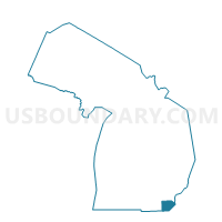
Outline

Summary
| Unique Area Identifier | 598349 |
| Name | Voting District 1152340000003 |
| County | Monroe County |
| State | Michigan |
| Area (square miles) | 17.28 |
| Land Area (square miles) | 17.02 |
| Water Area (square miles) | 0.25 |
| % of Land Area | 98.55 |
| % of Water Area | 1.45 |
| Latitude of the Internal Point | 41.95677780 |
| Longtitude of the Internal Point | -83.61492340 |
Maps


Graphs
Select a template below for downloading or customizing gragh for Voting District 1152340000003, Monroe County, Michigan


Neighbors
Neighoring Voting District (by Name) Neighboring Voting District on the Map
- Voting District 1152340000001, Monroe County, MI
- Voting District 1152340000002, Monroe County, MI
- Voting District 1154026000002, Monroe County, MI
- Voting District 1154918000001, Monroe County, MI
- Voting District 1155390000001, Monroe County, MI
- Voting District 1156690000001, Monroe County, MI
- Voting District 1156690000002, Monroe County, MI
- Voting District 1157714000001, Monroe County, MI
Top 10 Neighboring County Subdivision (by Population) Neighboring County Subdivision on the Map
- Dundee township, Monroe County, MI (6,759)
- Raisinville township, Monroe County, MI (5,816)
- Ida township, Monroe County, MI (4,964)
- Summerfield township, Monroe County, MI (3,308)
- London township, Monroe County, MI (3,048)
- Milan township, Monroe County, MI (1,601)
Top 10 Neighboring Place (by Population) Neighboring Place on the Map
Top 10 Neighboring Unified School District (by Population) Neighboring Unified School District on the Map
- Dundee Community Schools, MI (8,731)
- Ida Public School District, MI (8,134)
- Summerfield School District, MI (4,543)
Top 10 Neighboring State Legislative District Lower Chamber (by Population) Neighboring State Legislative District Lower Chamber on the Map
Top 10 Neighboring State Legislative District Upper Chamber (by Population) Neighboring State Legislative District Upper Chamber on the Map
Top 10 Neighboring 111th Congressional District (by Population) Neighboring 111th Congressional District on the Map
Top 10 Neighboring Census Tract (by Population) Neighboring Census Tract on the Map
- Census Tract 8308, Monroe County, MI (6,759)
- Census Tract 8328, Monroe County, MI (4,964)
- Census Tract 8329, Monroe County, MI (4,454)
- Census Tract 8307, Monroe County, MI (3,665)
- Census Tract 8310, Monroe County, MI (3,056)
- Census Tract 8306, Monroe County, MI (3,050)
- Census Tract 8309, Monroe County, MI (2,760)